Bar nearby Benjie's Bar
Trinidad and Tobago
Bar nearby Benjie's Bar
Benjie's Bar
Lachoos Road, Penal, TT Trinidad and Tobago
contacts phone
:
+1-868
website:
www.facebook.com
Latitude:
10.1666532
, Longitude:
-61.4533641
larger map & directions
read more
nearest Bar
35 m
Shantils Rest & Bar
Lachoos Road, Penal
Bar
read more
912 m
Millington Bar
Penal
Bar
read more
915 m
FrenZone bar
Ali Mohammed Avenue, Penal
Bar
read more
928 m
Club J's Bar and Lounge
1244 ., Penal
Bar
read more
985 m
Flags Sports Bar
Katwaroo Trace, Penal
Bar
read more
3.781 km
Troopers Restaurant and Bar
67 Sanahee Trace, Mohess Road., Debe
Bar
read more
9.654 km
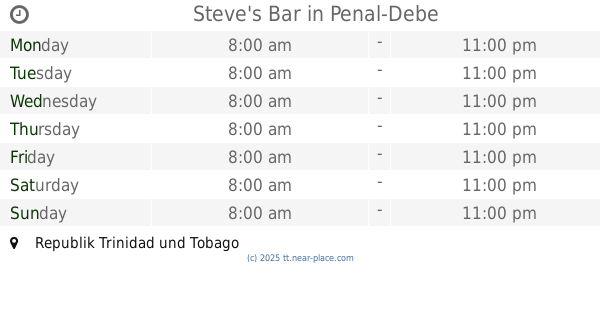
Steve's Bar
Trinidad & Tobago
Bar
read more
10.998 km
CRO-BAR Cross Bar And Lounge
Prince Charles
Bar
read more
11.054 km
Infinity Bar & Lounge
San Fernando
Bar
read more
12.031 km
Marshall's Korner
32 Cipero Street, San Fernando
Bar
read more
12.274 km
Thè Edge Restaurant And Bar
Keate Street, San Fernando
Bar
read more
12.314 km
Wilson's Place
Simpson Brown Terrace, San Fernando
Bar
read more
12.386 km
CoffeeServiceman Bar
Marryat Street, San Fernando
Bar
read more
12.47 km
Alex Moms Friend
San Fernando
Bar
read more
12.482 km
Splash 2 pub
17, Betty Street, San Fernando
Bar
read more
12.498 km
High Chaparral Bar
Naparima Mayaro Road, San Fernando
Bar
read more
12.522 km
Seon Bar
Royal Rd, San Fernando, Trinidad and, Tobago
Bar
read more
12.727 km
Royal Cup
San Fernando
Bar
read more
13.244 km
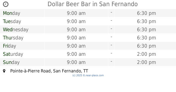
Dollar Beer Bar
97b, Pointe-à-Pierre Road, San Fernando
Bar
read more
13.266 km
Dawn's Cuisine Rest. & Bar
San Fernando
Bar
read more
13.456 km
Happy Hill
San Fernando
Bar
read more
13.469 km
Ohio Recreation Club
Jarvis Street, San Fernando
Bar
read more
13.64 km
'D' Office Restaurant & Lounge
Lambie Street, San Fernando
Bar
read more
13.715 km
Island Beer Chill & Grill
SouthPark, Michael Rahael Boulevard, San Fernando
Bar
read more
13.719 km
Bottlestop wines,spirits,events
San Fernando
Bar
read more
📑
all categories
Accounting
Administrative area level 1
Airport
Art gallery
Atm
Bakery
Bank
Bar
Beauty salon
Bicycle store
Book store
Bus station
Cafe
Campground
Car dealer
Car rental
Car repair
Car wash
Casino
Cemetery
Church
City hall
Clothing store
Convenience store
Country
Courthouse
Dentist
Department store
Doctor
Electrician
Electronics store
Embassy
Establishment
Finance
Fire station
Florist
Food
Funeral home
Furniture store
Gas station
General contractor
Grocery or supermarket
Gym
Hair care
Hardware store
Health
Hindu Temple
Home goods store
Hospital
Insurance agency
Intersection
Jewelry store
Laundry
Lawyer
Library
Liquor store
Local government office
Locality
Locksmith
Lodging
Meal delivery
Meal takeaway
Mosque
Movie theater
Moving company
Museum
Natural feature
Neighborhood
Night club
Painter
Park
Parking
Pet store
Pharmacy
Physiotherapist
Place of worship
Plumber
Point of interest
Police
Political
Post office
Premise
Real estate agency
Restaurant
Roofing contractor
Route
School
Shoe store
Shopping mall
Spa
Stadium
Storage
Store
Supermarket
Taxi stand
Transit station
Travel agency
University
Veterinary care
Zoo
sublocality level 1
↑